From lookout to lokout, we will reveal the history and oddities of the villages and landscapes we have visited.
This April, the MACMA team put our backpacks on our backs and went to explore some lookouts with wonderful views of La Marina Alta, this experience is designed to be done by car, motorbike or bicycle and discover the region in a different way, from a bird's eye view. A three-day itinerary that combines landscapes with culture, heritage and gastronomy. From viewpoint to viewpoint, corner to corner, from the beach to the highest point of La Marina, we will reveal the history and oddities of the towns and landscapes we have visited on this trip, which we have enjoyed and now hope that the enjoy yourself too.

A BIT OF HISTORY. We know where we come from to decide where we are going.
From MACMA, the experience we have proposed for the month of April has to do with the natural heritage of the region. We are talking about viewpoints, structures designed to make available to the population a space with a wide view of the entire environment. We will travel and walk through the mountains, easily accessible agricultural paths and trails to observe everything that surrounds the Marina Alta. But first, let's talk a little about these structures throughout history.
The viewpoint is a place to observe the landscape. We can distinguish two types. On the one hand, we find the natural viewpoints, which are those "balconies" that protrude from a mountain, cliff or ridge, or near a river or sea. On the other hand, we have the artificial viewpoints, those that are built by humans and that can have their origin either to be a strategic point of forest surveillance, or because of the high tourist attraction, these viewpoints we can found both in the natural and urban areas. The first are usually balconies or platforms on a mountain or in interpretation centers, built of iron or wood, to make them more impressive. In the case of urban viewpoints, they are built in buildings, restaurants or homes to offer a decorated space, with services and accessible where you can enjoy a unique landscape.
Although the function of offering a panoramic view does not change, its purpose does. Currently, we use the viewpoints as a tourist and cultural advertising space where you can go and learn a bit of history that has been lived in them, such as battles or discoveries among others, in addition to being able to take incredible photographs.
A very different use from what they had in the past. These were used according to different objectives such as having a view of the environment to see the passage of animals, control the main communication routes... But above all they are strategic points to monitor the environment that surrounds it, control possible military attacks and facilitate rapid action against the enemy.
Regardless of the use we give it, what is clear is what this space brings and transmits to us, a feeling of peace, tranquility and freedom when you can see the landscape, feel the wind rushing in front of you, hear the noise of animals in the wild and the smell of nature in its greatest splendor.
Curiosities:
- In La Marina Alta we have two networks of viewpoints, which have their own routes that can be found on the Descobrim La Marina Alta website: The route of the viewpoints of Alcalalí and the route of the viewpoints of Xàbia.
- In different viewpoints that we propose we can see the same landscape from different points of view, even see other viewpoints that we have passed.

PROPOSED DAYS. Step by step we are making our way.
The experience takes place over three days, where we will visit different viewpoints and high places that allow us to observe the region from another point of view, enjoy our mountains and our most emblematic natural heritage.
Day 1 - Les Vall de la Marina and the Girona river
We start the itinerary in the municipality of Pego, an area of great environmental importance and a rice producer. Completely surrounded by mountains except to the east, where the Mediterranean Sea is, we started in Paseo Atzeneta (La Verdala), as it is an accessible place with good parking. We will go by car to the calvary and look for the path that goes up to the Pla d'Almiserà , along this path we will see the Xical mountains, the Gellibre, we will pass through the Canal ravine until we reach the highest point of the path, at the height of the crossing that goes up to the fort of Almiserà and the antennas, we will park and walk up to be able to enjoy the wonderful views that can reach 75 km in the round on clear days: On the right, the municipalities of Atzúbia and Pego, Marjal de Pego-Oliva and in the background the Mediterranean Sea. To the left, the Vall de Gallinera between the Foradà and Almirant mountain ranges made up of eight villages: Benirrama, Benialí, Benissivà, Benitaia, la Carroja, Alpatró, Llombai and Benissili, which we can also glimpse. On the way down we will be able to see the mountain of Tossal dels Corbs and the dry stone banks that were once planted with dry crops (almonds, carob trees and olive trees) or at times even with vineyards.
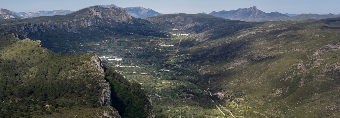 Views from Almiserà
We will return to the car again and head towards the Mirador del Xap , at the end of the Vall de Gallinera, the area has been declared a flora micro-reserve, you must be especially careful when driving, because the flora and fauna are very fragile , so it is necessary to respect the environment. From here we will have a better view of Foradà and the municipalities that make up the Valley, as well as the landmark with the neighboring region of Safor.
Then we will go to the municipality of Vall d'Ebo , located in the western interior of the region, in the upper course of the Girona river, where one of the most famous caves in the area, the Cova del Rull , is located , full of of stalactites and stalagmites that create shapes of various colors, with the option of a guided tour.
In the Ebo Valley it is a good place to make a stop and treat yourself to a good breakfast, since despite being a small town it has a good range of hotels. At the end we will visit the municipality and follow the path along the CV-712 to the Mirador del Barranc de l'Infern , we will stop for a few minutes to feel the joy of the vision of the depth of the ravine, of the Juvees and the Vall de Laguar, next destination of our itinerary.
During the descent along the Ebo road we will have wonderful views of Pego and the Marjal and the sea in the background as well as the perfect view of the Ambra castle in the term of Pego. Once down, on the CV-715 towards Sagra, we will go to the Vall de Laguar , located in a very mountainous area in the interior of the region, in the upper course of the Girona river and submerged between this basin in the course high and between the Penyó or Cavall Verd mountains in the south and the Migdia and Ebo or les Aspres mountains in the north. Formed by three towns: Campell or Poble de Baix, Fleix or Poble d'Enmig, and Benimaurell or Poble de Dalt.
We will go up to Benimaurell and along the Camí del Plan we will go to the Coll de la Garga (Collao), from there we will have magnificent views of the Barranc de l'Infern - this ravine is known as one of the most impressive canyons in the Valencian Country - and also from the whole area of the Vall de Laguar, Orba and the Rectory, a little further we can also glimpse Ondara and Dénia nestled between the Montgó and Segària mountains, and in the background the Mediterranean.
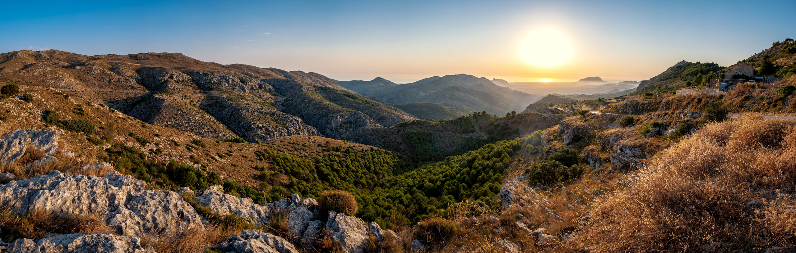 Views from Coll de la Garga
After enjoying these emblematic landscapes, it's time to fill your stomach. In La Vall de Laguar there are different restaurants where you can taste the typical cuisine of the area, accompanied by good views and a welcoming atmosphere. There are also different routes that connect the municipalities that make it up, from the MACMA we invite you to take a walk through the lavadores de Laguar and visit the Fontilles Sanatorium , historically linked to the disease of leprosy.
To end the day, we suggest you watch the sunset from the antennas of Segària , an elevated point where we can climb by car or on foot along the SL-CV 109 La Segària de Benimeli , a route with great cultural wealth and history in which we can observe a marked Iberian and Arab imprint. From the aerials we can perfectly observe how La Marina Alta region is completely surrounded by large mountain ranges that are clearly identifiable on clear days and of which we can highlight: Bèrnia closing the region to the south and a natural landmark with the Marina Baixa, the Serrella in the bordering the Comtat region, the Marjal and the Bullent river, a natural landmark with the Safor region from which we can also glimpse its coast and even see the Mondúver. To spend the night, we recommend spending the night in the Rectoria, Orba or Parcent area, since the next day we will start from the Mirador del Coll de Rates.
Day 2 - The Pop Valley and the Gorgos River
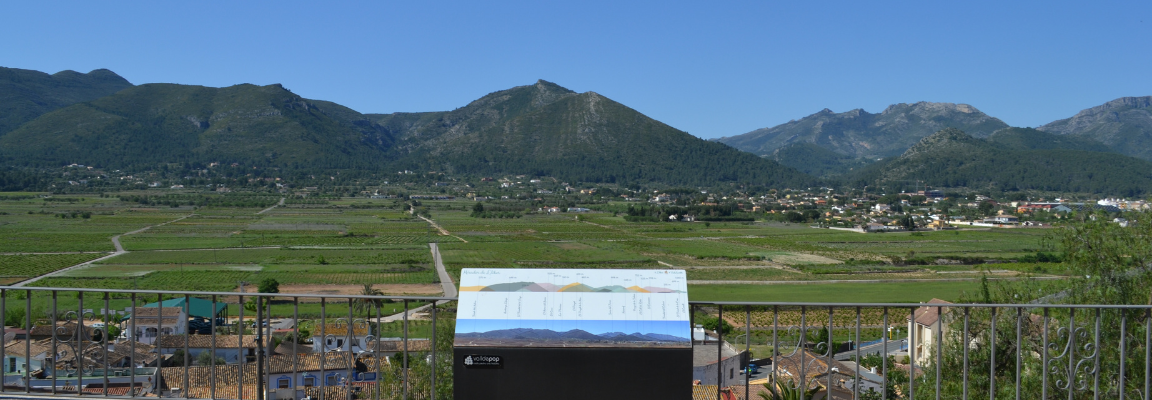
The second day we will start from Parcent to go up to the Mirador del Coll de Rates , located on the Carrascar mountain, a mountain massif located to the west of Parcent and to the northeast of Tàrbena, the Marina Baixa, which separates the Vall of Pop and the Algar Valley. At the Mirador we will find a model of the topography describing the views we can glimpse, also from this point we will be able to see most of the route we will take today.
 Views from Coll de Rates
We will go down again to Parcent and along the CV-720 we will go to the town of Alcalalí , the town is nestled in the middle of the Vall de Pop, crossed by the Gorgos river. The town is flanked by the Seguili mountain, the Carrascar, the Coll de Rates and the peak of Aixa. There is the Urban Route of the Viewpoints , but we will visit the Cocó del Garbell Viewpoint where we will be able to observe the entire panorama of the Gorgos River and the mountains that surround it, and the Vall de Pop Viewpoint which is inside the Medieval Tower of the municipality , tower from where they watched for attacks by pirates and bandits coming through the Coll de Rates: You must check the opening hours at the Town Hall before visiting.
We will continue the itinerary, heading to Xaló , we chose to do the route on Saturday to go around the typical stops of the Rastro de Xaló, you will also find the Mercat de la Terra. Xaló has different shops where you can have breakfast, lunch or buy traditional products and from km 0. After walking around Xaló we will take the car to go to the neighboring town of Llíber , surrounded by the Sierra de Bèrnia and the Castell de la Solana , we will be able to enjoy places such as the source of Aixa, the departure of Marnes and Cau or the red rock.
We will leave the car to enter the streets of the municipality and look for the Mirador del Pla de Llíber , we invite you to do the #Vadesentits route , a route prepared with several scannable QR codes that will give you information about the history of Llíber d a different way, interacting with the five senses. The viewpoint is located in the calvary, between the Plans de Xaló, the Collado mountain, the Llíber hill and the Cuta ravine, the panorama it offers shows the true essence of the town, it is one of the few places in La Marina Alta that it has survived over time in the cultivation of vines, given that the vast majority were devastated with the arrival of phylloxera. Currently, the raisin continues to be one of the economic drivers and central element of many of the town's festivals.
 Views from the Mirador del Plan de Llíber
At the end of the visit to Llíber we will go to Senija , located in the south-eastern part of the interior of the region, which offers many attractions that must be visited, among which we highlight the following:
- The MOS , an outdoor urban art museum where the canvases are the facades of the houses.
- La Cova de la Garganta , shallow, but which was the refuge of a bandit called Tona, who robbed merchants coming or going along the Old Way of Valencia.
- La Creu de Senija , where we will go to contemplate the panorama of the entire Gorgos basin with the mouth at the foot of Montgó, the views of the municipality of Benissa with the Penyal d'Ifac and the Sierra d'Oltà in the background and up to the Torre del Cap d'Or de Moraira, a point we will visit on the third day of the experience.
To end the day we will go to the town of Pedreguer , located in the northern half of the region, in a fertile arable plain enclosed by the Gran mountain to the southwest and the Montgó to the northeast. Mirabarques Lookout was built on top of the mountain in 1998, the work of architect Lourdes Garcia Sogo, the structure stands on a circular platform, about 18 meters in diameter. It is a monument with a metal structure that supports a semicircular wooden platform. From there we can observe how the sun hides behind us and the panorama that leaves us of the municipalities and the coastal mountains such as Montgó.
The next day we will start from Cap de Sant Antoni, we recommend spending the night in a town on the slopes of Montgó.
Day 3 - La Marina Alta coast
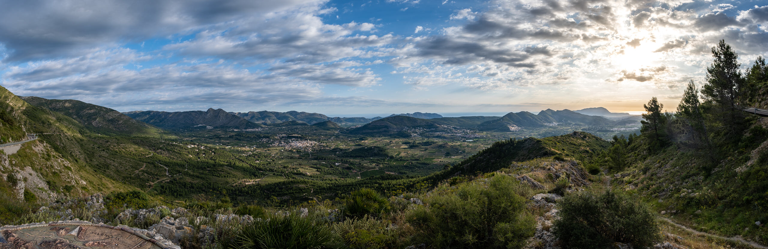
Today we will travel along the coast of the region, between cliffs and beaches, first we will visit Cap de Sant Antoni , in the natural park of Montgó, it has both geographic and landscape particularities, because it is subject to strong hydrodynamism that indicates a topography varied underwater with various substrates, such as posidonia, which make it unique and of great environmental richness. From here we will be able to observe Xàbia, we will have a unique view of its port and the coastal area, also in the background Cap Prim and Portitxol Island, Cap Negre, the antennas of Puig de la Llorença and if we turn our view we also have a unique panorama of Montgó.
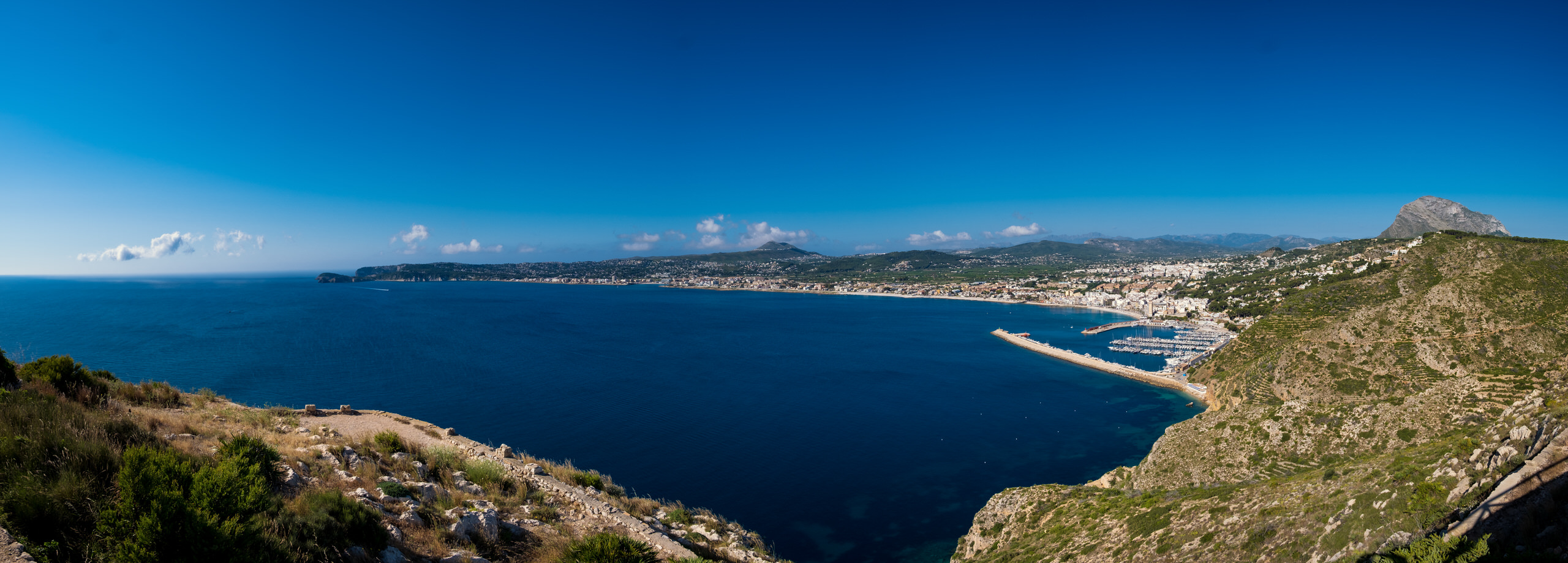 Views from Cap de Sant Antoni
We will continue on our way to the municipality of Xàbia , surrounded by sea and mountains, it is framed by the foothills of the Plains of Cap de Sant Antoni, to the north; the Montgó to the northwest; the valley of the Gorgos river that crosses the term from west to east; and to the south the mountains of Granadella and Cap de la Nau. Xàbia has a route, the Ruta dels Miradors , which covers the 13 most important viewpoints in the municipality by bicycle, is 27.2 kilometers long and lasts approximately three hours. We will visit the Ambolo viewpoint , the Cap de la Nau viewpoint and the Creu del Portitxol viewpoint , from these three points we will observe the coves and cliffs that make up the coast, the Discoverer's Island and the 'Illa del Portitxol, we will contemplate the sound of the waves breaking on the rocks, the flight of the seagulls and the spectacular views of the Mediterranean Sea, if the day is with us, from these points we will be able to observe the island on the horizon from Ibiza.
After visiting the coast of Xàbia and having breakfast at one of the viewpoints enjoying the scenery, we will head along the CV-747 to Poble Nou de Benitatxell , nestled in a spectacular location on La Marina Alta coast, between Cap de la Nau and Cap d'Or, between bluffs and cliffs that hide fishing grounds and the Llebeig, Moraig and Testos coves, with a remarkable underwater and geological natural heritage: an underground river, faults and caves by the sea.
Going up the hill of Llorença is the Mirador del Poble , which offers a great panorama of the entire urban center of Benitatxell, with its particular pyramidal design crowned by the bell tower. Around Poble Nou, there are the adjacent terms of Xàbia and Teulada.
In addition, on clear days it is possible to glimpse, towards the north, a great image of the profile of the Valencian coast, which recreates the marine limit until reaching the Gulf of Valencia. Turning south and inland towards the coast, you will find mountain formations such as Bèrnia, Oltà or the Penyal d'Ifac. It is a unique view, as the Mediterranean can be seen on both sides of our location.
We will continue the experience along the CV-737 towards Moraira , which together with the population center of Teulada form the municipality of Teulada, located on the coastal strip, in the south-eastern part of the region. Highlights include Moraira Castle , the Senillar Marsh and the Cap d'Or Tower , a 16th century defensive watchtower that was built in 1563 to protect the coast from possible pirate raids.
We will leave the car in the Cala del Portet car park to take the route that goes up to the tower, since along the path there are two viewpoints that overlook the coast of Cap d'Or , built of wood and in two areas where the tranquility of nature and the sound of the waves help us contemplate the wonderful views. Its field of vision extends from Cap de la Nau in the north to Penyal d'Ifac in the south, and on clear days it reaches the Serra Gelada.
 Views from the first viewpoint of the Torre del Cap d'Or
When we get off the route we can walk along the Portet beach and have lunch in a restaurant, in Teulada and Moraira it is very typical to have bull, arros a banda or paella with sardines and spinach, all conveniently accompanied with a good glass of wine of his vineyards.
To finish the experience we will go to the Mirador del Morro de Toix along the CV-746, a road that crosses the entire coast from Moraira to Calpe, passing through the different coves of Benissa.
When we arrive in Calpe we will look for the road that takes us to Morro de Toix, if we detour through the urban areas, we will be able to make a stop at the Red Wall , a building by the architect Ricardo Bofill with an architecture that adapts to the topography of the cliff where they are located. An architectural complex made up of two buildings: Xanadú and the Amphitheater.
Already at the Morro de Toix viewpoint , we will close the experience with the panorama of the Bay of Calpe and La Marina Alta coast and the Mediterranean Sea that the viewpoint leaves us, we will be able to glimpse all the points we have visited today, as well as see the panorama of Oltà and Bernia behind it. In addition, it is a strategic point to observe Ibiza on clear days and see how, beyond the Mascarat (geographic landmark and natural barrier of the region) the other Marina opens up with the incredible Altea and its iconic mountains: the Puig Campana and Ponoig.
** This experience is designed to be done in three days, although each person can adapt it to their abilities and preferences. From the MACMA we recommend that the route be done at the weekend, from Friday to Sunday, to be able to enjoy the Terra de Xaló market on Saturday. If you want to expand your experience and visit other high places, we recommend taking the routes that go up to the summit of Montgó and Fort de Bèrnia . In addition, if what you want is to expand the information or elements to visit in each town, you can go to the Descobrim La Marina Alta website and customize this route.
For the month of April there is a flurry of activities scheduled to celebrate Easter, we also have the Mitja Fava Fest in Poble Nou in Benitatxell, Fora d'Orbita in Orba, the 1st Agroecological and Territorial Fair in Parcent and the Meetings 2024 of the Valencian school in Pego. Consult all the cultural, youth and sports programming in our MACMA Guide.
You can follow April's experience using this map

AND MORE. On the table and in bed at the first cry.
 Where to buy |  where to eat |
 where to sleep |  Activities and others |