By way of springs, aqueducts, mills, caves and marshes.
On the northern edge of the area known as La Marina, nestled between mountains, there are valleys along which streams and rivers run until they get to the plains and form a marshland. The valley of the River Gallinera, the L'Atzúbia valley and the Pego valley are waterflows that have eaten away at the mountains over the course of millennia, so as to open breaches towards the lowest point, the wetlands known as La Marjal de Pego-Oliva, where water springs up from underground and creates one of the most important wet natural landscapes of the Valencian region.
Have you ever wondered how this marvel of nature came to exist? Our suggestion for today is to get to know firsthand the course taken by the water that feeds the La Marjal Natural Park, from its source up in the mountains, creating caves, chasms and, on the shaded side of the valleys, flowing from springs, until it reaches Mostalla and feeds the main aquifer of La Marjal, thereby creating the River Bullent.
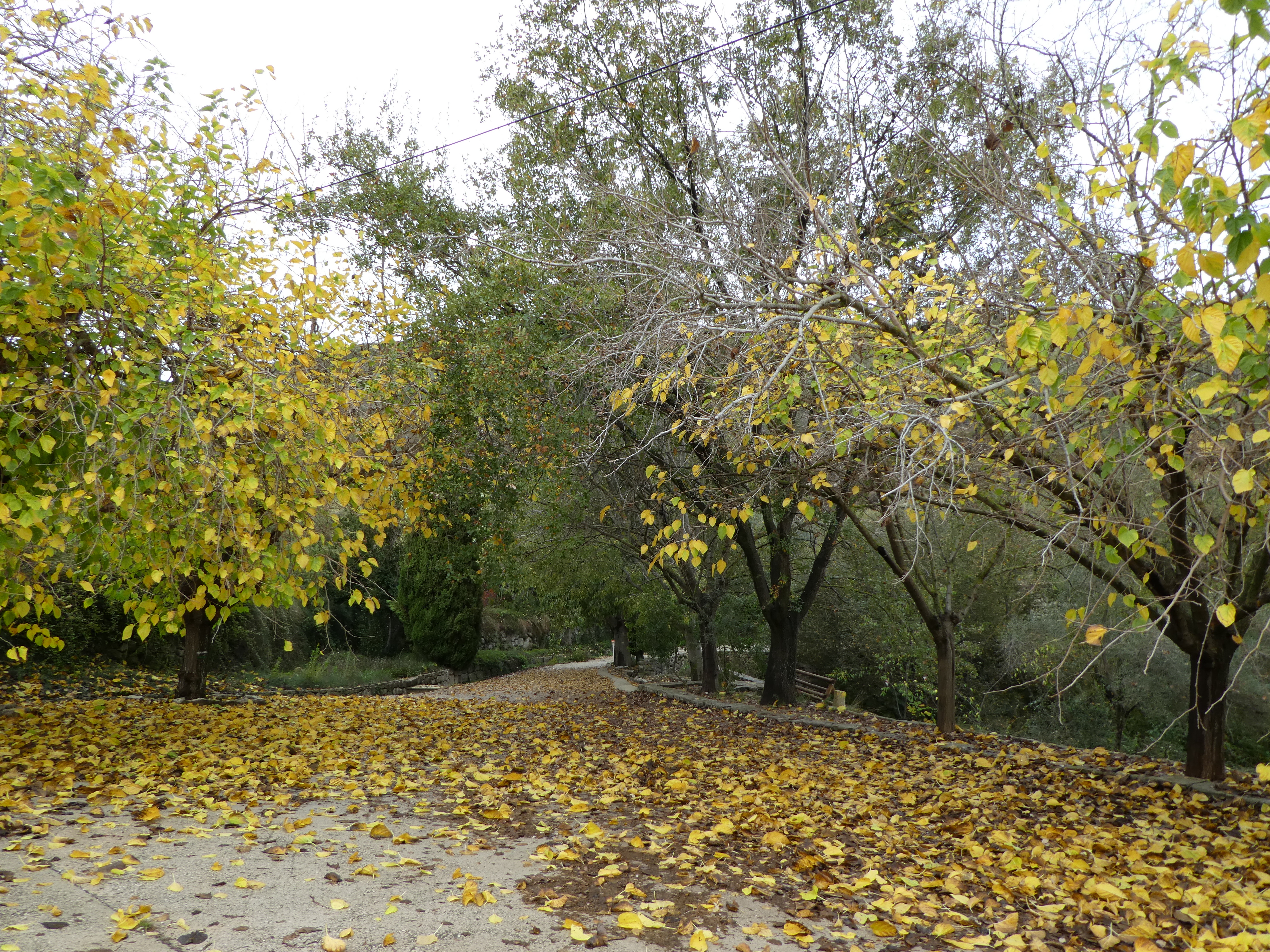
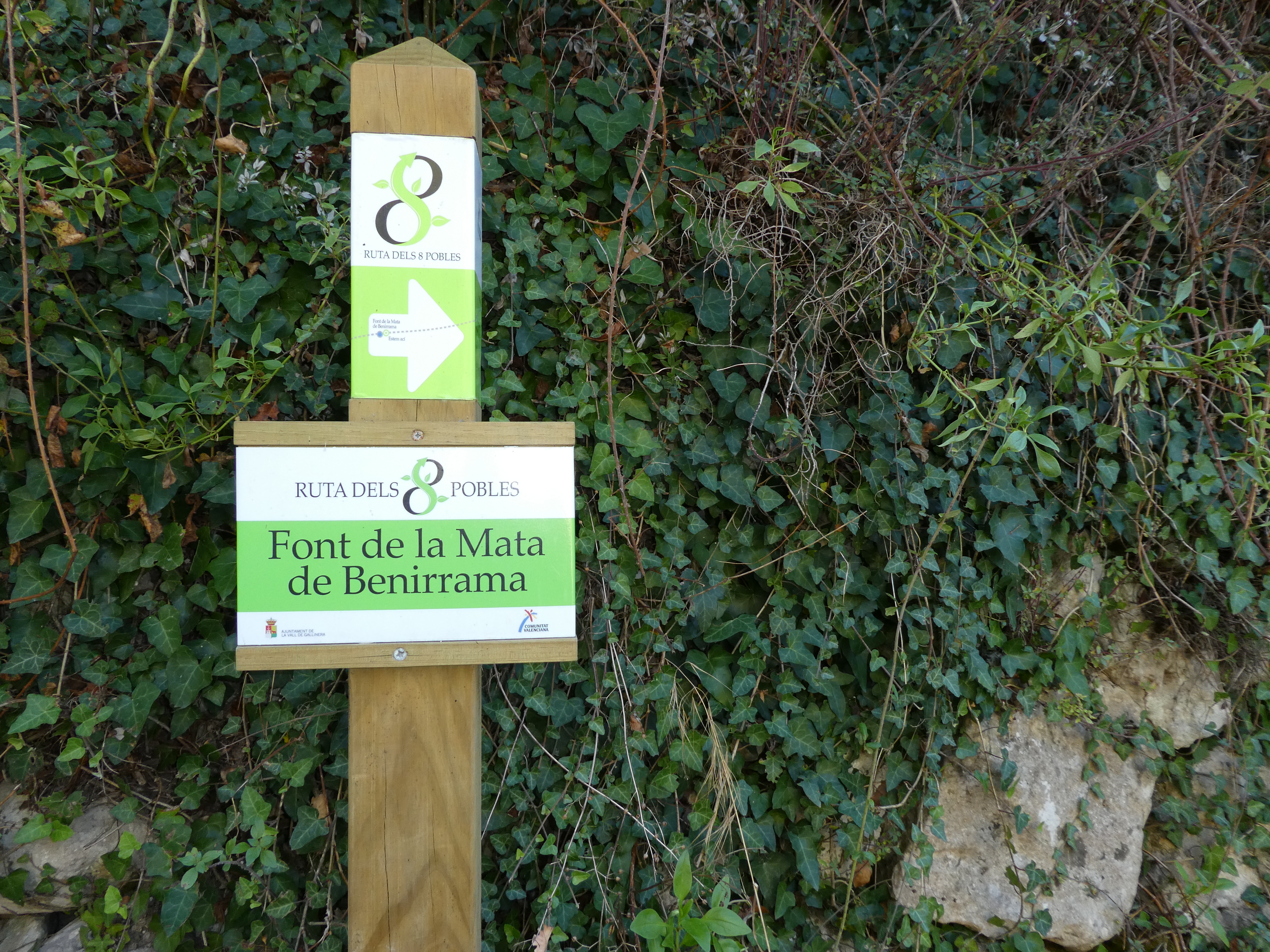
This route starts from the spring called La Font de la Mata, in Benissili, the last of the villages of the valley know as La Vall de Gallinera. This is where the so-called “Route of the 8 villages” starts and during this trail, which is marked with green and white indications, you will follow the course of the River Gallinera and also part of the old royal road (known locally as “camino real”). If there is one thing characteristic of this hike it is the fact that you can get to know the route taken by the water and the various types of hydraulic structures that the people of La Vall have built over a period of many centuries. Each village has outdoor communal washing places and springs or fountains that you can admire, but there are also other elements such as Uncle Quico's waterwheel or the mill in Benialí. The irrigated orchards and vegetable gardens surrounding the farmhouses of La Vall de Gallinera are living memory of the great Andalusian medieval heritage, with water channeled through small irrigation canals so as to be able to irrigate vegetable patches. The Route of the 8 villages of La Vall de Galllinera ends at another spring, also known as La Font de la Mata but this time located in the village of Benirrama, which is the last village of this municipality before crossing over into the territory of the villages of L'Atzúbia and Forna.
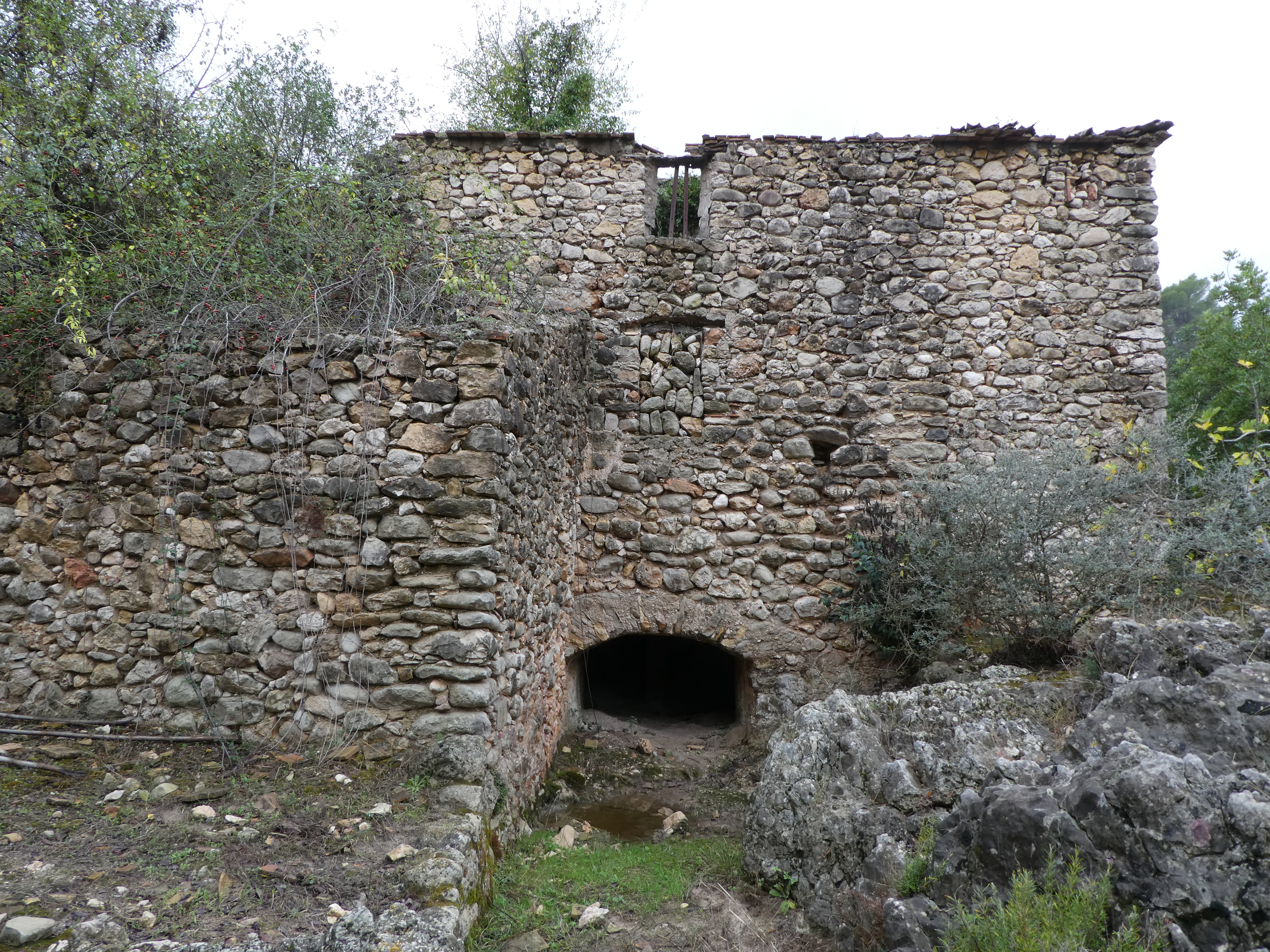
Although this specific path ends, your route continues and lets you discover other fundamental structures related to the River Gallinera: the flour mills. In this section, which lies between La Vall de Galllinera and L'Atzúbia, there are three watermills which were used to make flour: El Molí de Dalt (the upper mill), also known as the Millers' Mill and located within the municipality of La Vall de Galllinera, El Molí de Mig (the middle mill), also called Porra (the boundary marker between the two municipalities) and El Molí de Baix (the lower mill) or the Serafins' Mill, located within the municipal boundaries of L'Atzúbia. The stories of all these mills begin in the 18th century, coinciding with a period of demographic increase in La Marina Alta during which new farmlands were being created. As a consequence, the vast majority of the buildings and infrastructure used to transform cereals (threshing squares and watermills) were built during the aforementioned period, and they were all regularly used up until the 20s or 30s of the 20th century.
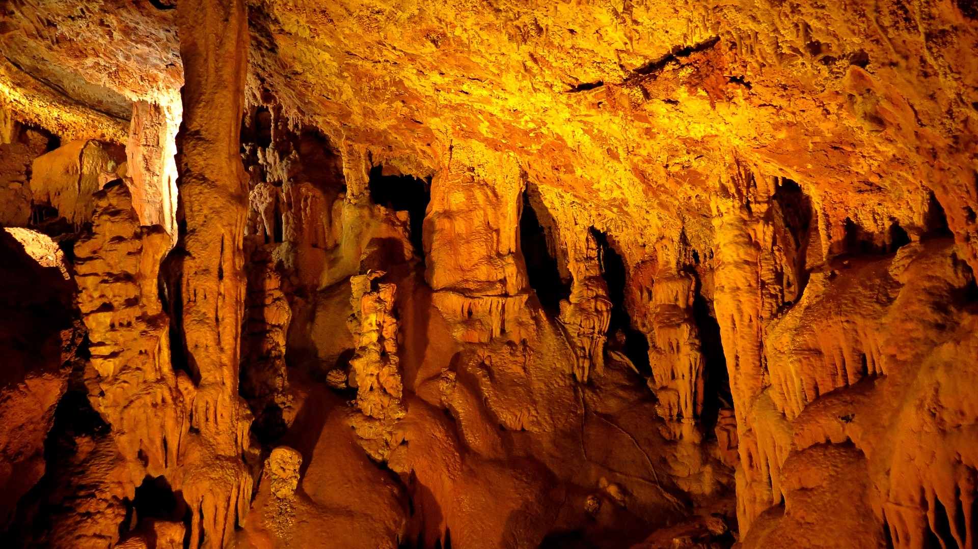
The River Gallinera slivers away towards the village of Forna, but before continuing along this route there is an obligatory stop to be made: El Tossal del Llop (the wolf's hill) in L'Atzúbia. There you can visit a delightful cave, hidden from sight and popularly known as La Cova Canelobre, which is a synthesis of what characterises our mountains: an underground karstic system by way of which water makes its way through the guts of the mountains. It is therefore not surprising that this area is full of galleries, chasms and caves, within which the droplets of water have created natural sculptural wonders in the form of stalactites and stalagmites. To visit the cave, it is necessary to have previously contacted L'Atzúbia's town hall. From L'Atzúbia, so as to see La Marjal and its wonders from a bird's-eye view, you have to follow a hiking route that begins at the municipal swimming pool and permits you to skirt the small mountain known as El Tossal de la Moleta, ending up at the top of El Carritxar, which is the highest part of the Serra de Mostalla mountain range. The best time to reach to the top is first thing in the morning, when the sun rises and turns to gold the entire sheet of water of La Marjal. From this high point it is possible to take a new trail which has recently been approved by the Pego Hiking Centre (Centre Excursionista de Pego), going down through Serra de Mostalla towards the valley of Pego. Our last recommendation is to visit the Muntanyeta Verde park and route, from where you can see the River Bullent meandering from the heights, and from where you can also observe the entire Natural Park, with the new cultivated areas of rice and the omnipotent Serra de Segària mountain range, like a stone giant asleep in the background. Your eyes will fall upon a sheet of water that looks like a mirror, fed by all the water that runs through La Vall de Gallinera, L'Atzúbia and Forna; water that the local people have learned to take advantage of so as to power mills but which they have also learned to tame in order to irrigate croplands and provide food. The same water that has the strength to pierce entire mountains but also the delicacy to create wonders, drop by drop and over periods of thousands of years, forming banderoles, stalactites, stalagmites and stone columns. And, finally, water that springs from the depths of Serra de Mostalla until it comes out again to create another fundamental river of this entire water system, the River Bullent, which is the main river that feeds the La Marjal Natural Park, arousing many passions throughout history, from the 16th century to the 20th century.
Elements to visit during the tour:
La Vall de Gallinera L'Atzúbia Pego
La Marjal La Font de la Mata Ruta dels 8 pobles
Forna Cova Canelobre Serra de Mostalla Segària
Núria Gómez Bolufer
Tècnica de cultura i patrimoni